- About project
- Collections
- Indexes
- Recently viewed
-
RCIN Repositories
-
 INSTYTUT ARCHEOLOGII I ETNOLOGII POLSKIEJ AKADEMII NAUK
-
 INSTYTUT BADAŃ LITERACKICH POLSKIEJ AKADEMII NAUK
-
 INSTYTUT BADAWCZY LEŚNICTWA
-
 INSTYTUT BIOLOGII DOŚWIADCZALNEJ IM. MARCELEGO NENCKIEGO POLSKIEJ AKADEMII NAUK
-
 INSTYTUT BIOLOGII SSAKÓW POLSKIEJ AKADEMII NAUK
-
 INSTYTUT CHEMII FIZYCZNEJ PAN
-
 INSTYTUT CHEMII ORGANICZNEJ PAN
-
 INSTYTUT FILOZOFII I SOCJOLOGII PAN
-
 INSTYTUT GEOGRAFII I PRZESTRZENNEGO ZAGOSPODAROWANIA PAN
-
 INSTYTUT HISTORII im. TADEUSZA MANTEUFFLA POLSKIEJ AKADEMII NAUK
-
 INSTYTUT JĘZYKA POLSKIEGO POLSKIEJ AKADEMII NAUK
-
 INSTYTUT MATEMATYCZNY PAN
-
 INSTYTUT MEDYCYNY DOŚWIADCZALNEJ I KLINICZNEJ IM.MIROSŁAWA MOSSAKOWSKIEGO POLSKIEJ AKADEMII NAUK
-
 INSTYTUT PODSTAWOWYCH PROBLEMÓW TECHNIKI PAN
-
 INSTYTUT SLAWISTYKI PAN
-
 SIEĆ BADAWCZA ŁUKASIEWICZ - INSTYTUT TECHNOLOGII MATERIAŁÓW ELEKTRONICZNYCH
-
 MUZEUM I INSTYTUT ZOOLOGII POLSKIEJ AKADEMII NAUK
-
 INSTYTUT BADAŃ SYSTEMOWYCH PAN
-
 INSTYTUT BOTANIKI IM. WŁADYSŁAWA SZAFERA POLSKIEJ AKADEMII NAUK
-

Object
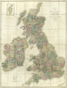
Title: Cary's reduction of his six sheet map of the British Isles : comprehending the whole of the turnpike roads, with the great rivers and the course of the different navigable canals, also the market and borough towns and villages adjoining the road, to which is added the actual distance from one market town to another, with the exact admeasurement to each from the metropolis
Publisher:
Place of publishing:
Description:
Skala [ca 1:920 000] ; 1 mapa : miedzior., ręcznie kolor. ; 121x94 cm ; Mapa poboczna: The Shetland Isles
Detailed Resource Type:
Format:
Rozmiar pliku 17,4 MB ; application/pdf
Resource Identifier:
Source:
CBGiOŚ. IGiPZ PAN, sygn. D.5020 [T.1/I/5] ; click here to follow the link
Language:
Rights:
Terms of use:
Digitizing institution:
Instytut Geografii i Przestrzennego Zagospodarowania Polskiej Akademii Nauk
Original in:
Projects co-financed by:
Program Operacyjny Innowacyjna Gospodarka, lata 2010-2014, Priorytet 2. Infrastruktura strefy B + R ; Unia Europejska. Europejski Fundusz Rozwoju Regionalnego
Access:
Object collections:
- Digital Repository of Scientific Institutes > Partners' collections > Institute of Geography and Spatial Organization PAS (IGiPZ PAN) > Library
- Digital Repository of Scientific Institutes > Partners' collections > Institute of Geography and Spatial Organization PAS (IGiPZ PAN) > Library > Maps and atlases
- Digital Repository of Scientific Institutes > Literature > Maps/Atlases
Last modified:
Oct 2, 2020
In our library since:
Oct 5, 2017
Number of object content downloads / hits:
89
All available object's versions:
https://www.rcin.org.pl/publication/50081
Show description in RDF format:
Show description in RDFa format:
Show description in OAI-PMH format:
| Edition name | Date |
|---|---|
| Cary, John (1755-1835), 1843, Cary's reduction of his six sheet map of the British Isles | Oct 2, 2020 |
Objects Similar
Russ, J. M. Hutson, A. M. Montgomery, W. I. Racey, P. A. Speakman, J. R.
Lewis, J. W.
Birks, J. D. S.
Richardson, J. H. Shore, R. F. Treweek, J. R.
Hutson, A. M.
McDonald, R. A. Webbon, C. Harris, S.
Lowe, V. P. W.
Smith, P. A. Smith, J. A. Tattersall, F. H. Lancaster, V. Natynczuk, S. E. Seymour, R. S.