- O repozytorium
- Kolekcje
- Indeksy
- Historia przeglądania
-
Repozytoria RCIN
-
 INSTYTUT ARCHEOLOGII I ETNOLOGII POLSKIEJ AKADEMII NAUK
-
 INSTYTUT BADAŃ LITERACKICH POLSKIEJ AKADEMII NAUK
-
 INSTYTUT BADAWCZY LEŚNICTWA
-
 INSTYTUT BIOLOGII DOŚWIADCZALNEJ IM. MARCELEGO NENCKIEGO POLSKIEJ AKADEMII NAUK
-
 INSTYTUT BIOLOGII SSAKÓW POLSKIEJ AKADEMII NAUK
-
 INSTYTUT CHEMII FIZYCZNEJ PAN
-
 INSTYTUT CHEMII ORGANICZNEJ PAN
-
 INSTYTUT FILOZOFII I SOCJOLOGII PAN
-
 INSTYTUT GEOGRAFII I PRZESTRZENNEGO ZAGOSPODAROWANIA PAN
-
 INSTYTUT HISTORII im. TADEUSZA MANTEUFFLA POLSKIEJ AKADEMII NAUK
-
 INSTYTUT JĘZYKA POLSKIEGO POLSKIEJ AKADEMII NAUK
-
 INSTYTUT MATEMATYCZNY PAN
-
 INSTYTUT MEDYCYNY DOŚWIADCZALNEJ I KLINICZNEJ IM.MIROSŁAWA MOSSAKOWSKIEGO POLSKIEJ AKADEMII NAUK
-
 INSTYTUT PODSTAWOWYCH PROBLEMÓW TECHNIKI PAN
-
 INSTYTUT SLAWISTYKI PAN
-
 SIEĆ BADAWCZA ŁUKASIEWICZ - INSTYTUT TECHNOLOGII MATERIAŁÓW ELEKTRONICZNYCH
-
 MUZEUM I INSTYTUT ZOOLOGII POLSKIEJ AKADEMII NAUK
-
 INSTYTUT BADAŃ SYSTEMOWYCH PAN
-
 INSTYTUT BOTANIKI IM. WŁADYSŁAWA SZAFERA POLSKIEJ AKADEMII NAUK
-

Obiekt
Dostępne formaty:
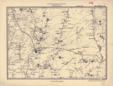
Pobierz wszystkieTytuł: XVI-18 (Mičurinsk) : RSFSR voronežskaâ obl. : masštab 3 versty v dŭjme
Twórca:
Data wydania/powstania:
Typ zasobu:
Inny tytuł:
Voenno-topografičeskaâ karta Evropejskoj Rossìi 1:126 000, XVI-18 (Mičurinsk)
Wydawca:
Miejsce wydania:
Opis:
Vremennoe izdanie ; Scale1:126 000 ; 1 map ; 43x60 cm, on sheet 52x68 cm ; So-called seriesi: Voenno-topografičeskaâ karta Evropejskoj Rossìi 1:126 000 ; In the margin information about sources: Karta sostavlena po starinnym sʺemkam proizvedennym do 1870 goda i po shematičeskim materialam raznyh vedomstv. In the neat line annotation: V-35-15 ; Prime meridian Pulkovo
Czasopismo/Seria/cykl:
Voenno-topografičeskaâ karta Evropejskoj Rossìi 1:126 000
Szczegółowy typ zasobu:
Format:
Identyfikator zasobu:
Źródło:
CBGiOŚ. IGiPZ PAN, call no. C.505/2 ; CBGiOŚ. IGiPZ PAN, call no. C.505/3 ; kliknij tutaj, żeby przejść
Język:
Zakres:
Prawa:
Zasady wykorzystania:
Digitalizacja:
Institute of Geography and Spatial Organization of the Polish Academy of Sciences
Lokalizacja oryginału:
Dofinansowane ze środków:
Dostęp:
Kolekcje, do których przypisany jest obiekt:
- Repozytorium Cyfrowe Instytutów Naukowych > Kolekcje Partnerów > Instytut Geografii i Przestrzennego Zagospodarowania PAN > Biblioteka Instytutu
- Repozytorium Cyfrowe Instytutów Naukowych > Kolekcje Partnerów > Instytut Geografii i Przestrzennego Zagospodarowania PAN > Biblioteka Instytutu > Mapy i atlasy
- Repozytorium Cyfrowe Instytutów Naukowych > Piśmiennictwo > Mapy/Atlasy
Data ostatniej modyfikacji:
2 paź 2020
Data dodania obiektu:
28 sty 2020
Liczba pobrań / odtworzeń:
23
Wszystkie dostępne wersje tego obiektu:
https://www.rcin.org.pl/publication/102706
Wyświetl opis w formacie RDF:
Wyświetl opis w formacie RDFa:
Wyświetl opis w formacie OAI-PMH:
| Nazwa wydania | Data |
|---|---|
| XVI-18 (Mičurinsk) : RSFSR voronežskaâ obl. : masštab 3 versty v dŭjme, [między 1934 i 1935] | 2 paź 2020 |
Obiekty Podobne
Związek Radziecki. Raboče-Krest'ânskaâ Krasnaâ Armiâ. Upravlenie voennyh topografov. Instytucja sprawcza. Wydawca
Związek Radziecki. Raboče-Krest'ânskaâ Krasnaâ Armiâ. Upravlenie voennyh topografov. Instytucja sprawcza. Wydawca
Związek Radziecki. Raboče-Krest'ânskaâ Krasnaâ Armiâ. Upravlenie voennyh topografov. Instytucja sprawcza. Wydawca
Związek Radziecki. Raboče-Krest'ânskaâ Krasnaâ Armiâ. Upravlenie voennyh topografov. Instytucja sprawcza. Wydawca
Związek Radziecki. Raboče-Krest'ânskaâ Krasnaâ Armiâ. Upravlenie voennyh topografov. Instytucja sprawcza Wydawca
Związek Radziecki. Raboče-Krest'ânskaâ Krasnaâ Armiâ. Upravlenie voennyh topografov. Instytucja sprawcza Wydawca
Związek Radziecki. Raboče-Krest'ânskaâ Krasnaâ Armiâ. Upravlenie voennyh topografov. Instytucja sprawcza Wydawca
Związek Radziecki. Raboče-Krest'ânskaâ Krasnaâ Armiâ. Upravlenie voennyh topografov. Instytucja sprawcza Wydawca