- About project
- Collections
- Indexes
- Recently viewed
-
RCIN Repositories
-
 INSTYTUT ARCHEOLOGII I ETNOLOGII POLSKIEJ AKADEMII NAUK
-
 INSTYTUT BADAŃ LITERACKICH POLSKIEJ AKADEMII NAUK
-
 INSTYTUT BADAWCZY LEŚNICTWA
-
 INSTYTUT BIOLOGII DOŚWIADCZALNEJ IM. MARCELEGO NENCKIEGO POLSKIEJ AKADEMII NAUK
-
 INSTYTUT BIOLOGII SSAKÓW POLSKIEJ AKADEMII NAUK
-
 INSTYTUT CHEMII FIZYCZNEJ PAN
-
 INSTYTUT CHEMII ORGANICZNEJ PAN
-
 INSTYTUT FILOZOFII I SOCJOLOGII PAN
-
 INSTYTUT GEOGRAFII I PRZESTRZENNEGO ZAGOSPODAROWANIA PAN
-
 INSTYTUT HISTORII im. TADEUSZA MANTEUFFLA POLSKIEJ AKADEMII NAUK
-
 INSTYTUT JĘZYKA POLSKIEGO POLSKIEJ AKADEMII NAUK
-
 INSTYTUT MATEMATYCZNY PAN
-
 INSTYTUT MEDYCYNY DOŚWIADCZALNEJ I KLINICZNEJ IM.MIROSŁAWA MOSSAKOWSKIEGO POLSKIEJ AKADEMII NAUK
-
 INSTYTUT PODSTAWOWYCH PROBLEMÓW TECHNIKI PAN
-
 INSTYTUT SLAWISTYKI PAN
-
 SIEĆ BADAWCZA ŁUKASIEWICZ - INSTYTUT TECHNOLOGII MATERIAŁÓW ELEKTRONICZNYCH
-
 MUZEUM I INSTYTUT ZOOLOGII POLSKIEJ AKADEMII NAUK
-
 INSTYTUT BADAŃ SYSTEMOWYCH PAN
-
 INSTYTUT BOTANIKI IM. WŁADYSŁAWA SZAFERA POLSKIEJ AKADEMII NAUK
-

Object
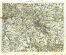
Title: Umgebungskarte von Lemberg : im Maasse 1:75.000
Subtitle:
Umgebungs - Karte von Lemberg im MaĹżsstabe 1:75 000
Contributor:
Kaiserlich-Königliches Militär-Geographisches Institut (Wiedeń)
Publisher:
General-Depôt des k. k. militär-geogr. Institutes ; R. Lechner's k.k. Ilof- und Univ. - Buchhandlung
Place of publishing:
Description:
Skala 1:75 000 ; 1 mapa : kolor. ; 55x69 cm, na ark. 62x75 cm, złoż. w okł. 21x13 cm ; Tytuł z okł ; Brak legendy ; Pod dolną ramką: Aus vier Specialkarten-Blättern zusammengesetzt. ; dwie podziałki liniowe ; Tyt. w jęz. niem, treść mapy w jęz. niem i pol.
Detailed Resource Type:
Format:
Resource Identifier:
Source:
CBGiOŚ. IGiPZ PAN, call no. Ds.7975 ; click here to follow the link
Language:
Rights:
Terms of use:
Digitizing institution:
Institute of Geography and Spatial Organization of the Polish Academy of Sciences
Original in:
Projects co-financed by:
Programme Innovative Economy, 2010-2014, Priority Axis 2. R&D infrastructure ; European Union. European Regional Development Fund
Access:
Object collections:
- Institute of Geography and Spatial Organization PAS (IGiPZ PAN) > Library
- Institute of Geography and Spatial Organization PAS (IGiPZ PAN) > Library > Maps and atlases
Last modified:
Oct 2, 2020
In our library since:
Jul 11, 2014
Number of object content downloads / hits:
329
All available object's versions:
https://www.rcin.org.pl/igipz/publication/53684
Show description in RDF format:
Show description in RDFa format:
Show description in OAI-PMH format:
| Edition name | Date |
|---|---|
| Umgebungskarte von Lemberg : im Maasse 1:75.000, 1880 | Oct 2, 2020 |
Objects Similar
Kummersberg, Carl von (1797–1877)
Kummersberg, Carl von (1797–1877)
Reymann, Daniel Gottlob (1759–1837) Oesfeld, Karl Wilhelm von (1781–1843)


