- About project
- Collections
- Indexes
- Recently viewed
-
RCIN Repositories
-
 INSTYTUT ARCHEOLOGII I ETNOLOGII POLSKIEJ AKADEMII NAUK
-
 INSTYTUT BADAŃ LITERACKICH POLSKIEJ AKADEMII NAUK
-
 INSTYTUT BADAWCZY LEŚNICTWA
-
 INSTYTUT BIOLOGII DOŚWIADCZALNEJ IM. MARCELEGO NENCKIEGO POLSKIEJ AKADEMII NAUK
-
 INSTYTUT BIOLOGII SSAKÓW POLSKIEJ AKADEMII NAUK
-
 INSTYTUT CHEMII FIZYCZNEJ PAN
-
 INSTYTUT CHEMII ORGANICZNEJ PAN
-
 INSTYTUT FILOZOFII I SOCJOLOGII PAN
-
 INSTYTUT GEOGRAFII I PRZESTRZENNEGO ZAGOSPODAROWANIA PAN
-
 INSTYTUT HISTORII im. TADEUSZA MANTEUFFLA POLSKIEJ AKADEMII NAUK
-
 INSTYTUT JĘZYKA POLSKIEGO POLSKIEJ AKADEMII NAUK
-
 INSTYTUT MATEMATYCZNY PAN
-
 INSTYTUT MEDYCYNY DOŚWIADCZALNEJ I KLINICZNEJ IM.MIROSŁAWA MOSSAKOWSKIEGO POLSKIEJ AKADEMII NAUK
-
 INSTYTUT PODSTAWOWYCH PROBLEMÓW TECHNIKI PAN
-
 INSTYTUT SLAWISTYKI PAN
-
 SIEĆ BADAWCZA ŁUKASIEWICZ - INSTYTUT TECHNOLOGII MATERIAŁÓW ELEKTRONICZNYCH
-
 MUZEUM I INSTYTUT ZOOLOGII POLSKIEJ AKADEMII NAUK
-
 INSTYTUT BADAŃ SYSTEMOWYCH PAN
-
 INSTYTUT BOTANIKI IM. WŁADYSŁAWA SZAFERA POLSKIEJ AKADEMII NAUK
-

Object
Available formats:
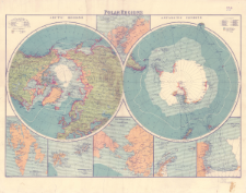
Download allTitle: Polar regions : Scale 1:35.000.000
Subtitle:
Arctic regions ; Antarctic regions
Institutional creator:
George Philip and Son ; London Geographical Institute
Publisher:
George Philip & Son, Ltd. ; The London Geographical Institute
Place of publishing:
Description:
Skala 1:35 000 000 ; 2 mapy na 1 arkuszu : kolorowe ; każda o średnicy 35 cm, na arkuszu 56 x 71 cm ; Mapy poboczne: Northern Greenland and Ellesmere Island scale 1:10,000,000; West Spitsbergen scale 1:2,500,000; Spitsbergen (Svalbard) and Franz Josef Land scale 1;10,000,000; The Bering Strait and Lower Yukon scale 1:10.000.000; South Shetland and Graham Land scale 1:10,000,000; Victoria Land scale 1:10,000,000 ; Na poszczególnych mapach zaznaczono m.in. trasy i daty ekspedycji odkrywczych i badawczych od końca XVIIII w. do 1916 r.
Detailed Resource Type:
Resource Identifier:
Source:
CBGiOŚ. IGiPZ PAN, sygn. PTG D.55 ; click here to follow the link
Language:
Coverage:
Rights:
Terms of use:
Digitizing institution:
Instytut Geografii i Przestrzennego Zagospodarowania Polskiej Akademii Nauk
Original in:
Projects co-financed by:
Access:
Object collections:
- Institute of Geography and Spatial Organization PAS (IGiPZ PAN) > Library > Maps and atlases
- Institute of Geography and Spatial Organization PAS (IGiPZ PAN) > Library > Selected collections > Polish Geographical Society Collection
Last modified:
Oct 25, 2021
In our library since:
Oct 20, 2021
Number of object content downloads / hits:
48
All available object's versions:
https://www.rcin.org.pl/igipz/publication/226395
Show description in RDF format:
Show description in RDFa format:
Show description in OAI-PMH format:
| Edition name | Date |
|---|---|
| Polar regions : Scale 1:35.000.000, [między 1918 i 1938] | Oct 25, 2021 |
Objects Similar
Houben, Heinrich Hubert (1875–1935) Volksverband der Bücherfreunde.
Mayer, Theodor Heinrich (1884–1949) Universum-Verlags-Gesellschaft (Wiedeń). Wydawca
Franklin, John (1786–1847) J. M. Dent & Sons. Wydawca E. P. Dutton
Nordenskiöld, Adolf Erik (1832–1901)
Maksimov, Sergej Vasil'evič (1831–1901) Tipografiâ tovariŝestva "Obŝestvennaâ pol'za". Wydawca
Nordenskiöld, Adolf Erik (1832–1901)
Schaade, Arthur (1883–1952) Geographisches Institut Carl Flemming und C. T. Wiskott (Głogów). Redaktor. Wydawca


