- O repozytorium
- Kolekcje
- Indeksy
- Historia przeglądania
-
Repozytoria RCIN
-
 INSTYTUT ARCHEOLOGII I ETNOLOGII POLSKIEJ AKADEMII NAUK
-
 INSTYTUT BADAŃ LITERACKICH POLSKIEJ AKADEMII NAUK
-
 INSTYTUT BADAWCZY LEŚNICTWA
-
 INSTYTUT BIOLOGII DOŚWIADCZALNEJ IM. MARCELEGO NENCKIEGO POLSKIEJ AKADEMII NAUK
-
 INSTYTUT BIOLOGII SSAKÓW POLSKIEJ AKADEMII NAUK
-
 INSTYTUT CHEMII FIZYCZNEJ PAN
-
 INSTYTUT CHEMII ORGANICZNEJ PAN
-
 INSTYTUT FILOZOFII I SOCJOLOGII PAN
-
 INSTYTUT GEOGRAFII I PRZESTRZENNEGO ZAGOSPODAROWANIA PAN
-
 INSTYTUT HISTORII im. TADEUSZA MANTEUFFLA POLSKIEJ AKADEMII NAUK
-
 INSTYTUT JĘZYKA POLSKIEGO POLSKIEJ AKADEMII NAUK
-
 INSTYTUT MATEMATYCZNY PAN
-
 INSTYTUT MEDYCYNY DOŚWIADCZALNEJ I KLINICZNEJ IM.MIROSŁAWA MOSSAKOWSKIEGO POLSKIEJ AKADEMII NAUK
-
 INSTYTUT PODSTAWOWYCH PROBLEMÓW TECHNIKI PAN
-
 INSTYTUT SLAWISTYKI PAN
-
 SIEĆ BADAWCZA ŁUKASIEWICZ - INSTYTUT TECHNOLOGII MATERIAŁÓW ELEKTRONICZNYCH
-
 MUZEUM I INSTYTUT ZOOLOGII POLSKIEJ AKADEMII NAUK
-
 INSTYTUT BADAŃ SYSTEMOWYCH PAN
-
 INSTYTUT BOTANIKI IM. WŁADYSŁAWA SZAFERA POLSKIEJ AKADEMII NAUK
-

Obiekt
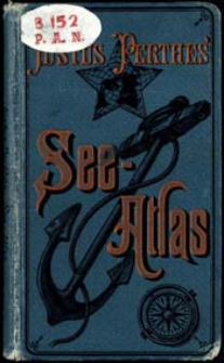
Tytuł: Justus Perthes' See-Atlas : 24 koloriete Karten in Kupferstich mit 127 Hafenplänen ; See-Atlas
Twórca:
Habenicht, Hermann (1844–1917) ; Knipping, Erwin : Oprac.
Data wydania/powstania:
Typ zasobu:
Wydawca:
Miejsce wydania:
Opis:
10 Aufl. ; Scales differ ; 1 atlas (48 p., 24 l.) : maps col. ; 18 cm ; Supplement to: Justus Perthes' Taschen-Atlas
Szczegółowy typ zasobu:
Format:
Identyfikator zasobu:
Źródło:
CBGiOŚ. IGiPZ PAN, call no. B.152 ; kliknij tutaj, żeby przejść
Język:
Prawa:
Zasady wykorzystania:
Digitalizacja:
Institute of Geography and Spatial Organization of the Polish Academy of Sciences
Lokalizacja oryginału:
Dofinansowane ze środków:
Programme Innovative Economy, 2010-2014, Priority Axis 2. R&D infrastructure ; European Union. European Regional Development Fund
Dostęp:
Kolekcje, do których przypisany jest obiekt:
- Instytut Geografii i Przestrzennego Zagospodarowania PAN > Biblioteka Instytutu
- Instytut Geografii i Przestrzennego Zagospodarowania PAN > Biblioteka Instytutu > Mapy i atlasy
Data ostatniej modyfikacji:
2 paź 2020
Data dodania obiektu:
19 lut 2013
Liczba pobrań / odtworzeń:
390
Wszystkie dostępne wersje tego obiektu:
https://www.rcin.org.pl/igipz/publication/19933
Wyświetl opis w formacie RDF:
Wyświetl opis w formacie RDFa:
Wyświetl opis w formacie OAI-PMH:
| Nazwa wydania | Data |
|---|---|
| Habenicht, Hermann (1844-1917), 1914, Justus Perthes' See-Atlas : 24 koloriete Karten in Kupferstich mit 127 Hafenplänen | 2 paź 2020 |
Obiekty Podobne
Stieler, Adolf (1775–1836) Habenicht, Hermann (1844–1917) Vogel, Carl (1828–1897) Justus Perthes (Gotha)
Towarzystwo Akcyjne Odlewni Czcionek i Drukarni S. Orgelbranda Synów
Kampen, Albert van (1842–1891) Geyer, Valentin
Scobel, Albert (1851–1912)
Scobel, Albert (1851–1912)
Nałkowski, Wacław (1851–1911) Świętochowski, Andrzej (1844–1928)
Stieler, Adolf (1775–1836) Justus Perthes (Gotha)


