- O repozytorium
- Kolekcje
- Indeksy
- Historia przeglądania
-
Repozytoria RCIN
-
 INSTYTUT ARCHEOLOGII I ETNOLOGII POLSKIEJ AKADEMII NAUK
-
 INSTYTUT BADAŃ LITERACKICH POLSKIEJ AKADEMII NAUK
-
 INSTYTUT BADAWCZY LEŚNICTWA
-
 INSTYTUT BIOLOGII DOŚWIADCZALNEJ IM. MARCELEGO NENCKIEGO POLSKIEJ AKADEMII NAUK
-
 INSTYTUT BIOLOGII SSAKÓW POLSKIEJ AKADEMII NAUK
-
 INSTYTUT CHEMII FIZYCZNEJ PAN
-
 INSTYTUT CHEMII ORGANICZNEJ PAN
-
 INSTYTUT FILOZOFII I SOCJOLOGII PAN
-
 INSTYTUT GEOGRAFII I PRZESTRZENNEGO ZAGOSPODAROWANIA PAN
-
 INSTYTUT HISTORII im. TADEUSZA MANTEUFFLA POLSKIEJ AKADEMII NAUK
-
 INSTYTUT JĘZYKA POLSKIEGO POLSKIEJ AKADEMII NAUK
-
 INSTYTUT MATEMATYCZNY PAN
-
 INSTYTUT MEDYCYNY DOŚWIADCZALNEJ I KLINICZNEJ IM.MIROSŁAWA MOSSAKOWSKIEGO POLSKIEJ AKADEMII NAUK
-
 INSTYTUT PODSTAWOWYCH PROBLEMÓW TECHNIKI PAN
-
 INSTYTUT SLAWISTYKI PAN
-
 SIEĆ BADAWCZA ŁUKASIEWICZ - INSTYTUT TECHNOLOGII MATERIAŁÓW ELEKTRONICZNYCH
-
 MUZEUM I INSTYTUT ZOOLOGII POLSKIEJ AKADEMII NAUK
-
 INSTYTUT BADAŃ SYSTEMOWYCH PAN
-
 INSTYTUT BOTANIKI IM. WŁADYSŁAWA SZAFERA POLSKIEJ AKADEMII NAUK
-

Obiekt
Dostępne formaty:
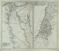
Pobierz wszystkieTytuł: Succincta Antiquioris Ægypti et Palæstinæ delineacio
Inny tytuł:
Ancienne Egypte et l'ancienne Palestine ; Alt Ægypten und Palæstina ; Succincta Antiquioris Aegypti et Palaestinae delineacio ; Alt Aegypten und Palaestina
Twórca instytucjonalny:
Königliche Akademie der Wissenschaften.
Wydawca:
Auspiciis Acad. Reg. Scient. et Eleg. Litt.
Miejsce wydania:
Opis:
Scale [ca 1:1 900 000] ; Scale [ca 1:2 800 000] ; 2 maps on 1 sheet : copperplate engraving, hand colored ; 22x33 cm, 17x33 cm ; Ferro's prime meridian determined by the cataloger ; The map of Egypt has four linear scales, and the map of Palestine has five linear scales ; Place and date of publication according to information from the biography of J. C. Rhode in: Tooley's dictionary of mapmakers. - Riverside, 2004 ; Title in Latin, French and German
Typ obiektu:
Szczegółowy typ zasobu:
Identyfikator zasobu:
Źródło:
CBGiOŚ. IGiPZ PAN, call no. PTG B.853[6] ; kliknij tutaj, żeby przejść
Język:
Zakres:
(E 34°10'-E 37°30'/N 35°10'-N 30°).
![]()
Prawa:
Zasady wykorzystania:
Digitalizacja:
Institute of Geography and Spatial Organization of the Polish Academy of Sciences
Lokalizacja oryginału:
Dofinansowane ze środków:
Dostęp:
Kolekcje, do których przypisany jest obiekt:
- Instytut Geografii i Przestrzennego Zagospodarowania PAN > Biblioteka Instytutu
- Instytut Geografii i Przestrzennego Zagospodarowania PAN > Biblioteka Instytutu > Mapy i atlasy
- Instytut Geografii i Przestrzennego Zagospodarowania PAN > Biblioteka Instytutu > Wybrane księgozbiory
- Instytut Geografii i Przestrzennego Zagospodarowania PAN > Biblioteka Instytutu > Wybrane księgozbiory > Księgozbiór Polskiego Towarzystwa Geograficznego
Data ostatniej modyfikacji:
14 kwi 2021
Data dodania obiektu:
14 kwi 2021
Liczba pobrań / odtworzeń:
20
Wszystkie dostępne wersje tego obiektu:
https://www.rcin.org.pl/igipz/publication/193755
Wyświetl opis w formacie RDF:
Wyświetl opis w formacie RDFa:
Wyświetl opis w formacie OAI-PMH:
| Nazwa wydania | Data |
|---|---|
| Rhode, Johann Christoph (1713 - 1786), [ca 1772], Succincta Antiquioris Ægypti et Palæstinæ delineacio | 14 kwi 2021 |
Obiekty Podobne
Harenberg, Johann Christoph (1696–1774)
Harenberg, Johann Christoph (1696–1774)


