- O repozytorium
- Kolekcje
- Indeksy
- Historia przeglądania
-
Repozytoria RCIN
-
 INSTYTUT ARCHEOLOGII I ETNOLOGII POLSKIEJ AKADEMII NAUK
-
 INSTYTUT BADAŃ LITERACKICH POLSKIEJ AKADEMII NAUK
-
 INSTYTUT BADAWCZY LEŚNICTWA
-
 INSTYTUT BIOLOGII DOŚWIADCZALNEJ IM. MARCELEGO NENCKIEGO POLSKIEJ AKADEMII NAUK
-
 INSTYTUT BIOLOGII SSAKÓW POLSKIEJ AKADEMII NAUK
-
 INSTYTUT CHEMII FIZYCZNEJ PAN
-
 INSTYTUT CHEMII ORGANICZNEJ PAN
-
 INSTYTUT FILOZOFII I SOCJOLOGII PAN
-
 INSTYTUT GEOGRAFII I PRZESTRZENNEGO ZAGOSPODAROWANIA PAN
-
 INSTYTUT HISTORII im. TADEUSZA MANTEUFFLA POLSKIEJ AKADEMII NAUK
-
 INSTYTUT JĘZYKA POLSKIEGO POLSKIEJ AKADEMII NAUK
-
 INSTYTUT MATEMATYCZNY PAN
-
 INSTYTUT MEDYCYNY DOŚWIADCZALNEJ I KLINICZNEJ IM.MIROSŁAWA MOSSAKOWSKIEGO POLSKIEJ AKADEMII NAUK
-
 INSTYTUT PODSTAWOWYCH PROBLEMÓW TECHNIKI PAN
-
 INSTYTUT SLAWISTYKI PAN
-
 SIEĆ BADAWCZA ŁUKASIEWICZ - INSTYTUT TECHNOLOGII MATERIAŁÓW ELEKTRONICZNYCH
-
 MUZEUM I INSTYTUT ZOOLOGII POLSKIEJ AKADEMII NAUK
-
 INSTYTUT BADAŃ SYSTEMOWYCH PAN
-
 INSTYTUT BOTANIKI IM. WŁADYSŁAWA SZAFERA POLSKIEJ AKADEMII NAUK
-

Obiekt
Dostępne formaty:
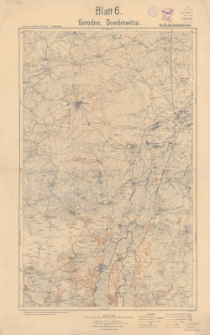
Pobierz wszystkieTytuł: Gorodno, Dombrowitza
Twórca:
Prusy. Landesaufnahme. Kartographische Abteilung. Wydawca
Data wydania/powstania:
Typ zasobu:
Inny tytuł:
Karte des westlichen Russlands. Kriegsausgabe ; Blatt 6 ; Karte des westlichen Rußlands 1:100 000 ; Blatt 6. Gorodno, Dombrowitza
Wydawca:
Kartogr. Abteilung der Kgl. Preuß Landesausnahme
Miejsce wydania:
Opis:
Scale 1:100 000 ; 1 map : color ; 57 x 37 cm, on sheet 68 x 45 cm ; Arkusz zbiorczy zawiera 2 arkusze mapy seryjnej Karte des westliche Russlands 1:100 000: T 34 Gorodno i T 35 Dombrowitza ; The combined sheet contains 2 sheets of the serial map Karte des westliche Russlands 1: 100,000: T 34 Gorodno and T 35 Dombrowitz ; Annotation in the margin: B.11.17 ; Nur für Dienstgebrauch ! ; Prime meridian Ferro
Czasopismo/Seria/cykl:
Karte des westlichen Rußlands 1:100 000
Szczegółowy typ zasobu:
Identyfikator zasobu:
Źródło:
CBGiOŚ. IGiPZ PAN, call no. C.135/5 ; kliknij tutaj, żeby przejść
Język:
Zakres:
Prawa:
Zasady wykorzystania:
Digitalizacja:
Institute of Geography and Spatial Organization of the Polish Academy of Sciences
Lokalizacja oryginału:
Dofinansowane ze środków:
Dostęp:
Kolekcje, do których przypisany jest obiekt:
- Instytut Geografii i Przestrzennego Zagospodarowania PAN > Biblioteka Instytutu
- Instytut Geografii i Przestrzennego Zagospodarowania PAN > Biblioteka Instytutu > Mapy i atlasy
- Instytut Geografii i Przestrzennego Zagospodarowania PAN > Biblioteka Instytutu > Wybrane księgozbiory > Księgozbiór Polskiego Towarzystwa Geograficznego
Data ostatniej modyfikacji:
22 gru 2020
Data dodania obiektu:
22 gru 2020
Liczba pobrań / odtworzeń:
38
Wszystkie dostępne wersje tego obiektu:
https://www.rcin.org.pl/igipz/publication/160173
Wyświetl opis w formacie RDF:
Wyświetl opis w formacie RDFa:
Wyświetl opis w formacie OAI-PMH:
| Nazwa wydania | Data |
|---|---|
| Gorodno, Dombrowitza, druk 1917 | 22 gru 2020 |
Obiekty Podobne
Dokaupil, Roman (18...- 19...). Redaktor Straka, J. Redaktor Bloschitz, Rudolf Macoun, V. Redaktor


