- O repozytorium
- Kolekcje
- Indeksy
- Historia przeglądania
-
Repozytoria RCIN
-
 INSTYTUT ARCHEOLOGII I ETNOLOGII POLSKIEJ AKADEMII NAUK
-
 INSTYTUT BADAŃ LITERACKICH POLSKIEJ AKADEMII NAUK
-
 INSTYTUT BADAWCZY LEŚNICTWA
-
 INSTYTUT BIOLOGII DOŚWIADCZALNEJ IM. MARCELEGO NENCKIEGO POLSKIEJ AKADEMII NAUK
-
 INSTYTUT BIOLOGII SSAKÓW POLSKIEJ AKADEMII NAUK
-
 INSTYTUT CHEMII FIZYCZNEJ PAN
-
 INSTYTUT CHEMII ORGANICZNEJ PAN
-
 INSTYTUT FILOZOFII I SOCJOLOGII PAN
-
 INSTYTUT GEOGRAFII I PRZESTRZENNEGO ZAGOSPODAROWANIA PAN
-
 INSTYTUT HISTORII im. TADEUSZA MANTEUFFLA POLSKIEJ AKADEMII NAUK
-
 INSTYTUT JĘZYKA POLSKIEGO POLSKIEJ AKADEMII NAUK
-
 INSTYTUT MATEMATYCZNY PAN
-
 INSTYTUT MEDYCYNY DOŚWIADCZALNEJ I KLINICZNEJ IM.MIROSŁAWA MOSSAKOWSKIEGO POLSKIEJ AKADEMII NAUK
-
 INSTYTUT PODSTAWOWYCH PROBLEMÓW TECHNIKI PAN
-
 INSTYTUT SLAWISTYKI PAN
-
 SIEĆ BADAWCZA ŁUKASIEWICZ - INSTYTUT TECHNOLOGII MATERIAŁÓW ELEKTRONICZNYCH
-
 MUZEUM I INSTYTUT ZOOLOGII POLSKIEJ AKADEMII NAUK
-
 INSTYTUT BADAŃ SYSTEMOWYCH PAN
-
 INSTYTUT BOTANIKI IM. WŁADYSŁAWA SZAFERA POLSKIEJ AKADEMII NAUK
-

Obiekt
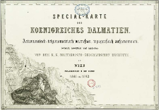
Tytuł: Special-Karte des Koenigreiches Dalmatien
Twórca:
Kaiserlich-Königliches Militär-Geographisches Institut (Wiedeń)
Data wydania/powstania:
Typ zasobu:
Wydawca:
K. K. Militaerisch-Geografisches Institute
Miejsce wydania:
Opis:
Scale 1:144 000 ; Maps (22 sheets) : copperplate engraving ; 34x48 cm or smaller, on sheets 39x51 cm, in cover 40x52 cm ; Artificial atlas. Sheet Nro. XIX title, sheet Nro. 15 1/2 sheet index and legend of a map , sheet Nro. IV legend of a map, sheet Nro XII table of trigonometric points, sheet Nro. XVII bar scales, sheet Nro. XX table of administrative division and statistical date ; Astronomisch-trigonometrisch vermessen, topografisch aufgenommen, reduzirt, gezeichnet und gestochen von dem K. K. Militaerisch-Geografischen Institute
Szczegółowy typ zasobu:
Format:
File size 27,6 MB ; image/x.djvu
Identyfikator zasobu:
Źródło:
CBGiOŚ. IGiPZ PAN, call no. B.1652 ; kliknij tutaj, żeby przejść
Język:
Prawa:
Zasady wykorzystania:
Digitalizacja:
Institute of Geography and Spatial Organization of the Polish Academy of Sciences
Lokalizacja oryginału:
Dofinansowane ze środków:
Programme Innovative Economy, 2010-2014, Priority Axis 2. R&D infrastructure ; European Union. European Regional Development Fund
Dostęp:
Kolekcje, do których przypisany jest obiekt:
- Instytut Geografii i Przestrzennego Zagospodarowania PAN > Biblioteka Instytutu
- Instytut Geografii i Przestrzennego Zagospodarowania PAN > Biblioteka Instytutu > Mapy i atlasy
Data ostatniej modyfikacji:
2 paź 2020
Data dodania obiektu:
12 mar 2012
Liczba pobrań / odtworzeń:
414
Wszystkie dostępne wersje tego obiektu:
https://www.rcin.org.pl/igipz/publication/15398
Wyświetl opis w formacie RDF:
Wyświetl opis w formacie RDFa:
Wyświetl opis w formacie OAI-PMH:
| Nazwa wydania | Data |
|---|---|
| Special-Karte des Koenigreiches Dalmatien, 1861-1863 | 2 paź 2020 |
Obiekty Podobne
Kaiserlich-Königliches Militär-Geographisches Institut (Wiedeń)
Mährisch-schlesischer Sudeten-Gebirgsverein Kaiserlich-Königliches Militär-Geographisches Institut (Wiedeń)
Kaiserlich-Königliches Militär-Geographisches Institut (Wiedeń)
Kaiserlich-Königliches Militär-Geographisches Institut (Wiedeń)
Kaiserlich-Königliches Militär-Geographisches Institut (Wiedeń)
Tomaszewski, Adam (1895–1945) Kaiserlich-Königliches Militär-Geographisches Institut (Wiedeń)
Reymann, Daniel Gottlob (1759–1837) Oesfeld, Karl Wilhelm von (1781–1843)


