- O repozytorium
- Kolekcje
- Indeksy
- Historia przeglądania
-
Repozytoria RCIN
-
 INSTYTUT ARCHEOLOGII I ETNOLOGII POLSKIEJ AKADEMII NAUK
-
 INSTYTUT BADAŃ LITERACKICH POLSKIEJ AKADEMII NAUK
-
 INSTYTUT BADAWCZY LEŚNICTWA
-
 INSTYTUT BIOLOGII DOŚWIADCZALNEJ IM. MARCELEGO NENCKIEGO POLSKIEJ AKADEMII NAUK
-
 INSTYTUT BIOLOGII SSAKÓW POLSKIEJ AKADEMII NAUK
-
 INSTYTUT CHEMII FIZYCZNEJ PAN
-
 INSTYTUT CHEMII ORGANICZNEJ PAN
-
 INSTYTUT FILOZOFII I SOCJOLOGII PAN
-
 INSTYTUT GEOGRAFII I PRZESTRZENNEGO ZAGOSPODAROWANIA PAN
-
 INSTYTUT HISTORII im. TADEUSZA MANTEUFFLA POLSKIEJ AKADEMII NAUK
-
 INSTYTUT JĘZYKA POLSKIEGO POLSKIEJ AKADEMII NAUK
-
 INSTYTUT MATEMATYCZNY PAN
-
 INSTYTUT MEDYCYNY DOŚWIADCZALNEJ I KLINICZNEJ IM.MIROSŁAWA MOSSAKOWSKIEGO POLSKIEJ AKADEMII NAUK
-
 INSTYTUT PODSTAWOWYCH PROBLEMÓW TECHNIKI PAN
-
 INSTYTUT SLAWISTYKI PAN
-
 SIEĆ BADAWCZA ŁUKASIEWICZ - INSTYTUT TECHNOLOGII MATERIAŁÓW ELEKTRONICZNYCH
-
 MUZEUM I INSTYTUT ZOOLOGII POLSKIEJ AKADEMII NAUK
-
 INSTYTUT BADAŃ SYSTEMOWYCH PAN
-
 INSTYTUT BOTANIKI IM. WŁADYSŁAWA SZAFERA POLSKIEJ AKADEMII NAUK
-

Obiekt
Dostępne formaty:
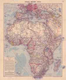
Pobierz wszystkieTytuł: Afrique = Afrika = Africa
Inny tytuł:
Westermanns Generalkarten, Nr.2 ; Afrika Maßstab 1:12 000 000 ; Afrika ; Africa
Wydawca:
Miejsce wydania:
Braunschweig ; Berlin ; Hamburg
Opis:
Scale 1:12 000 000 ; Entworften in flächentreuer Azimutalprojektion ; 1 map : color ; 80x65 cm, on sheet 87x74 cm ; Ancillary maps: Azoren ; Kapverdische Inseln
Czasopismo/Seria/cykl:
Szczegółowy typ zasobu:
Format:
Identyfikator zasobu:
Źródło:
CBGiOŚ. IGiPZ PAN, call no. P.T.G.D.542 ; kliknij tutaj, żeby przejść
Język:
Zakres:
Prawa:
Zasady wykorzystania:
Digitalizacja:
Institute of Geography and Spatial Organization of the Polish Academy of Sciences
Lokalizacja oryginału:
Dofinansowane ze środków:
Dostęp:
Kolekcje, do których przypisany jest obiekt:
- Instytut Geografii i Przestrzennego Zagospodarowania PAN > Biblioteka Instytutu > Mapy i atlasy
- Instytut Geografii i Przestrzennego Zagospodarowania PAN > Biblioteka Instytutu > Wybrane księgozbiory > Księgozbiór Polskiego Towarzystwa Geograficznego
Data ostatniej modyfikacji:
2 paź 2020
Data dodania obiektu:
21 sty 2020
Liczba pobrań / odtworzeń:
45
Wszystkie dostępne wersje tego obiektu:
https://www.rcin.org.pl/igipz/publication/108083
Wyświetl opis w formacie RDF:
Wyświetl opis w formacie RDFa:
Wyświetl opis w formacie OAI-PMH:
| Nazwa wydania | Data |
|---|---|
| Afrique, 1941 | 2 paź 2020 |
Obiekty Podobne
Stany Zjednoczone. Army Map Service. Wydawca Stany Zjednoczone. Army. Office of the Chief Engineers. Redaktor
Velhagen & Klasing. Wydawca
Bumstead, Albert Holt (1875–1940) National Geographic Society. National Geographic Maps
Bibliographisches Institut (Lipsk). Wydawca
R. Lechner <Wilhelm Müller> Universitätsbuchhandlung (Wiedeń). Wydawca


