Object
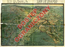
Title: Polska od Bałtyku = View of Poland from the Baltic Sea
Subtitle:
View of Poland from the Baltic Sea
Contributor:
Zwoliński, Tadeusz (1893–1955) : Rys. ; Polska. Ministerstwo Komunikacji (1918-1939). Wydawnictwo
Publisher:
Wydawnictwo Ministerstwa Komunikacji ; (Zakł. Graf. E. i Dra K. Koziańskich)
Place of publishing:
Description:
Skala nieokreślona ; 1 mapa : kolor. ; 65x94 cm, na ark. 75x105 cm ; Tyt. z mapy ; Orientacja południowa ; Mapy Turystyczne Polski 1850-1980 : wykaz chronologiczno-regionalny. - Warszawa, 1985. s. 24, poz. 4 ; Tyt. w jęz. ang. i pol.; legenda równol. w jęz. fr. i pol.
Detailed Resource Type:
Format:
Resource Identifier:
Source:
CBGiOŚ. IGiPZ PAN, call no. PTG D.1176 [m.ogólnogeogr.30] ; click here to follow the link
Language:
Rights:
Rights Reserved - Restricted Access
Terms of use:
Digitizing institution:
Institute of Geography and Spatial Organization of the Polish Academy of Sciences
Original in:
Projects co-financed by:
Programme Innovative Economy, 2010-2014, Priority Axis 2. R&D infrastructure ; European Union. European Regional Development Fund
Access:
Object collections:
- Institute of Geography and Spatial Organization PAS (IGiPZ PAN) > Library
- Institute of Geography and Spatial Organization PAS (IGiPZ PAN) > Library > Maps and atlases
- Institute of Geography and Spatial Organization PAS (IGiPZ PAN) > Library > Selected collections > Polish Geographical Society Collection
Last modified:
Oct 2, 2020
In our library since:
Jun 24, 2013
Number of object content downloads / hits:
24
All available object's versions:
https://www.rcin.org.pl/igipz/publication/43294
Show description in RDF format:
Show description in RDFa format:
Show description in OAI-PMH format:
| Edition name | Date |
|---|---|
| Zwoliński, Tadeusz (1893-1955). Rys., 1934, Polska od Bałtyku = View of Poland from the Baltic Sea | Oct 2, 2020 |
Objects Similar
Romer, Eugeniusz (1871–1954) Szumański, Teofil Instytut Kartograficzny im. Eugeniusza Romera

 INSTYTUT ARCHEOLOGII I ETNOLOGII POLSKIEJ AKADEMII NAUK
 INSTYTUT BADAŃ LITERACKICH POLSKIEJ AKADEMII NAUK
 INSTYTUT BADAWCZY LEŚNICTWA
 INSTYTUT BIOLOGII DOŚWIADCZALNEJ IM. MARCELEGO NENCKIEGO POLSKIEJ AKADEMII NAUK
 INSTYTUT BIOLOGII SSAKÓW POLSKIEJ AKADEMII NAUK
 INSTYTUT CHEMII FIZYCZNEJ PAN
 INSTYTUT CHEMII ORGANICZNEJ PAN
 INSTYTUT FILOZOFII I SOCJOLOGII PAN
 INSTYTUT GEOGRAFII I PRZESTRZENNEGO ZAGOSPODAROWANIA PAN
 INSTYTUT HISTORII im. TADEUSZA MANTEUFFLA POLSKIEJ AKADEMII NAUK
 INSTYTUT JĘZYKA POLSKIEGO POLSKIEJ AKADEMII NAUK
 INSTYTUT MATEMATYCZNY PAN
 INSTYTUT MEDYCYNY DOŚWIADCZALNEJ I KLINICZNEJ IM.MIROSŁAWA MOSSAKOWSKIEGO POLSKIEJ AKADEMII NAUK
 INSTYTUT PODSTAWOWYCH PROBLEMÓW TECHNIKI PAN
 INSTYTUT SLAWISTYKI PAN
 SIEĆ BADAWCZA ŁUKASIEWICZ - INSTYTUT TECHNOLOGII MATERIAŁÓW ELEKTRONICZNYCH
 MUZEUM I INSTYTUT ZOOLOGII POLSKIEJ AKADEMII NAUK
 INSTYTUT BADAŃ SYSTEMOWYCH PAN
 INSTYTUT BOTANIKI IM. WŁADYSŁAWA SZAFERA POLSKIEJ AKADEMII NAUK


