Object
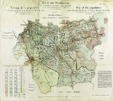
Title: Karte der Bevölkerunk des ostmährisch-schlesische Industriegebietes : nach dem amtlichen Volkszählungsergebnissen vom Jahre 1910 = Tableau de la population du Territoire de la Moravie et Silésie de l'Est, d'après les recensements officiels de 1910 = Map of the population of the Manufacturin District of Eastern Moravia and Silesia, according to the official results of the census of 1910
Subtitle:
Tableau de la population du Territoire de la Moravie et Silésie de l'Est, d'après les recensements officiels de 1910 ; Map of the population of the Manufacturin District of Eastern Moravia and Silesia, according to the official results of the census of 1910
Contributor:
Obratschay, V : Oprac. ; Prochaska, Karl (1855–1920) : Druk.
Publisher:
Druck- und Verlagshaus Karl Prochaska
Place of publishing:
Description:
Skala [ca 1:150 000] ; 1 mapa : litogr., kolor. ; na ark. 52x58 cm ; Data wyd. na podst. wpisu do księgi akcesji ; W lewym dolnym rogu mapy objaśniena kolorów i szrafów użytych to przedstawienia procentowego udziału ludności polskiej, czeskiej i niemieckiej. Na mapie zaznaczono sieć rzeczną i sieć drogową ; Tyt., legenda i informacje tekstowe równol. w jęz. ang, fr. i niem.
Detailed Resource Type:
Format:
Rozmiar pliku 2,0 MB ; image/x.djvu
Resource Identifier:
Source:
CBGiOŚ. IGiPZ PAN, sygn. D.20136 [II.7B-34] ; CBGiOŚ. IGiPZ PAN, sygn. D.2580 [II.7B-26] ; click here to follow the link
Language:
Rights:
Terms of use:
Digitizing institution:
Instytut Geografii i Przestrzennego Zagospodarowania Polskiej Akademii Nauk
Original in:
Projects co-financed by:
Program Operacyjny Innowacyjna Gospodarka, lata 2010-2014, Priorytet 2. Infrastruktura strefy B + R ; Unia Europejska. Europejski Fundusz Rozwoju Regionalnego
Access:
Object collections:
- Institute of Geography and Spatial Organization PAS (IGiPZ PAN) > Library
- Institute of Geography and Spatial Organization PAS (IGiPZ PAN) > Library > Maps and atlases
Last modified:
Oct 2, 2020
In our library since:
Nov 29, 2011
Number of object content downloads / hits:
314
All available object's versions:
https://www.rcin.org.pl/igipz/publication/1853
Show description in RDF format:
Show description in RDFa format:
Show description in OAI-PMH format:
Objects Similar
Popiołek, Franciszek (1868–1960) Golachowski, T. Oprac.
Sikora, Wincenty (1878–1958)
Spett, Jakub
Wiercieński, Henryk Wojciech Jakub (1843–1923) Rokicki, A. Rys.
Spett, J. Oprac.

 INSTYTUT ARCHEOLOGII I ETNOLOGII POLSKIEJ AKADEMII NAUK
 INSTYTUT BADAŃ LITERACKICH POLSKIEJ AKADEMII NAUK
 INSTYTUT BADAWCZY LEŚNICTWA
 INSTYTUT BIOLOGII DOŚWIADCZALNEJ IM. MARCELEGO NENCKIEGO POLSKIEJ AKADEMII NAUK
 INSTYTUT BIOLOGII SSAKÓW POLSKIEJ AKADEMII NAUK
 INSTYTUT CHEMII FIZYCZNEJ PAN
 INSTYTUT CHEMII ORGANICZNEJ PAN
 INSTYTUT FILOZOFII I SOCJOLOGII PAN
 INSTYTUT GEOGRAFII I PRZESTRZENNEGO ZAGOSPODAROWANIA PAN
 INSTYTUT HISTORII im. TADEUSZA MANTEUFFLA POLSKIEJ AKADEMII NAUK
 INSTYTUT JĘZYKA POLSKIEGO POLSKIEJ AKADEMII NAUK
 INSTYTUT MATEMATYCZNY PAN
 INSTYTUT MEDYCYNY DOŚWIADCZALNEJ I KLINICZNEJ IM.MIROSŁAWA MOSSAKOWSKIEGO POLSKIEJ AKADEMII NAUK
 INSTYTUT PODSTAWOWYCH PROBLEMÓW TECHNIKI PAN
 INSTYTUT SLAWISTYKI PAN
 SIEĆ BADAWCZA ŁUKASIEWICZ - INSTYTUT TECHNOLOGII MATERIAŁÓW ELEKTRONICZNYCH
 MUZEUM I INSTYTUT ZOOLOGII POLSKIEJ AKADEMII NAUK
 INSTYTUT BADAŃ SYSTEMOWYCH PAN
 INSTYTUT BOTANIKI IM. WŁADYSŁAWA SZAFERA POLSKIEJ AKADEMII NAUK


