- About project
- Collections
- Indexes
- Recently viewed
-
RCIN Repositories
-
 INSTYTUT ARCHEOLOGII I ETNOLOGII POLSKIEJ AKADEMII NAUK
-
 INSTYTUT BADAŃ LITERACKICH POLSKIEJ AKADEMII NAUK
-
 INSTYTUT BADAWCZY LEŚNICTWA
-
 INSTYTUT BIOLOGII DOŚWIADCZALNEJ IM. MARCELEGO NENCKIEGO POLSKIEJ AKADEMII NAUK
-
 INSTYTUT BIOLOGII SSAKÓW POLSKIEJ AKADEMII NAUK
-
 INSTYTUT CHEMII FIZYCZNEJ PAN
-
 INSTYTUT CHEMII ORGANICZNEJ PAN
-
 INSTYTUT FILOZOFII I SOCJOLOGII PAN
-
 INSTYTUT GEOGRAFII I PRZESTRZENNEGO ZAGOSPODAROWANIA PAN
-
 INSTYTUT HISTORII im. TADEUSZA MANTEUFFLA POLSKIEJ AKADEMII NAUK
-
 INSTYTUT JĘZYKA POLSKIEGO POLSKIEJ AKADEMII NAUK
-
 INSTYTUT MATEMATYCZNY PAN
-
 INSTYTUT MEDYCYNY DOŚWIADCZALNEJ I KLINICZNEJ IM.MIROSŁAWA MOSSAKOWSKIEGO POLSKIEJ AKADEMII NAUK
-
 INSTYTUT PODSTAWOWYCH PROBLEMÓW TECHNIKI PAN
-
 INSTYTUT SLAWISTYKI PAN
-
 SIEĆ BADAWCZA ŁUKASIEWICZ - INSTYTUT TECHNOLOGII MATERIAŁÓW ELEKTRONICZNYCH
-
 MUZEUM I INSTYTUT ZOOLOGII POLSKIEJ AKADEMII NAUK
-
 INSTYTUT BADAŃ SYSTEMOWYCH PAN
-
 INSTYTUT BOTANIKI IM. WŁADYSŁAWA SZAFERA POLSKIEJ AKADEMII NAUK
-

Object
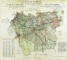
Title: Karte der Bevölkerunk des ostmährisch-schlesische Industriegebietes : nach dem amtlichen Volkszählungsergebnissen vom Jahre 1910 = Tableau de la population du Territoire de la Moravie et Silésie de l'Est, d'après les recensements officiels de 1910 = Map of the population of the Manufacturin District of Eastern Moravia and Silesia, according to the official results of the census of 1910
Subtitle:
Map of the population of the Manufacturin District of Eastern Moravia and Silesia, according to the official results of the census of 1910 ; Tableau de la population du Territoire de la Moravie et Silésie de l'Est, d'après les recensements officiels de 1910
Contributor:
Obratschay, V : Oprac. ; Prochaska, Karl (1855–1920) : Druk.
Publisher:
Druck- und Verlagshaus Karl Prochaska
Place of publishing:
Description:
Scale [ca 1:150 000] ; 1 map : lithogr., col. ; on sheet 52x58 cm
Detailed Resource Type:
Format:
File size 2,0 MB ; image/x.djvu
Resource Identifier:
Source:
CBGiOŚ. IGiPZ PAN, call no. D.20136 [II.7B-34] ; CBGiOŚ. IGiPZ PAN, call no. D.2580 [II.7B-26] ; click here to follow the link
Language:
Rights:
Terms of use:
Digitizing institution:
Institute of Geography and Spatial Organization of the Polish Academy of Sciences
Original in:
Projects co-financed by:
Programme Innovative Economy, 2010-2014, Priority Axis 2. R&D infrastructure ; European Union. European Regional Development Fund
Access:
Object collections:
- Institute of Geography and Spatial Organization PAS (IGiPZ PAN) > Library
- Institute of Geography and Spatial Organization PAS (IGiPZ PAN) > Library > Maps and atlases
Last modified:
Oct 2, 2020
In our library since:
Nov 29, 2011
Number of object content downloads / hits:
314
All available object's versions:
https://www.rcin.org.pl/igipz/publication/1853
Show description in RDF format:
Show description in RDFa format:
Show description in OAI-PMH format:
Objects Similar
Popiołek, Franciszek (1868–1960) Golachowski, T. Oprac.
Sikora, Wincenty (1878–1958)
Spett, Jakub
Wiercieński, Henryk Wojciech Jakub (1843–1923) Rokicki, A. Rys.


