- O repozytorium
- Kolekcje
- Indeksy
- Historia przeglądania
-
Repozytoria RCIN
-
 INSTYTUT ARCHEOLOGII I ETNOLOGII POLSKIEJ AKADEMII NAUK
-
 INSTYTUT BADAŃ LITERACKICH POLSKIEJ AKADEMII NAUK
-
 INSTYTUT BADAWCZY LEŚNICTWA
-
 INSTYTUT BIOLOGII DOŚWIADCZALNEJ IM. MARCELEGO NENCKIEGO POLSKIEJ AKADEMII NAUK
-
 INSTYTUT BIOLOGII SSAKÓW POLSKIEJ AKADEMII NAUK
-
 INSTYTUT CHEMII FIZYCZNEJ PAN
-
 INSTYTUT CHEMII ORGANICZNEJ PAN
-
 INSTYTUT FILOZOFII I SOCJOLOGII PAN
-
 INSTYTUT GEOGRAFII I PRZESTRZENNEGO ZAGOSPODAROWANIA PAN
-
 INSTYTUT HISTORII im. TADEUSZA MANTEUFFLA POLSKIEJ AKADEMII NAUK
-
 INSTYTUT JĘZYKA POLSKIEGO POLSKIEJ AKADEMII NAUK
-
 INSTYTUT MATEMATYCZNY PAN
-
 INSTYTUT MEDYCYNY DOŚWIADCZALNEJ I KLINICZNEJ IM.MIROSŁAWA MOSSAKOWSKIEGO POLSKIEJ AKADEMII NAUK
-
 INSTYTUT PODSTAWOWYCH PROBLEMÓW TECHNIKI PAN
-
 INSTYTUT SLAWISTYKI PAN
-
 SIEĆ BADAWCZA ŁUKASIEWICZ - INSTYTUT TECHNOLOGII MATERIAŁÓW ELEKTRONICZNYCH
-
 MUZEUM I INSTYTUT ZOOLOGII POLSKIEJ AKADEMII NAUK
-
 INSTYTUT BADAŃ SYSTEMOWYCH PAN
-
 INSTYTUT BOTANIKI IM. WŁADYSŁAWA SZAFERA POLSKIEJ AKADEMII NAUK
-

Obiekt
Dostępne formaty:
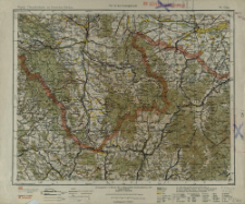
Pobierz wszystkieTytuł: Glatz
Twórca:
Prusy. Landesaufnahme. Kartographische Abteilung. Redaktor. Wydawca
Data wydania/powstania:
Typ zasobu:
Inny tytuł:
Topogr. Übersichtskarte des Deutschen Reiches ; 145. Glatz ; Topographische Übersichtskarte des Deutschen Reiches 1:200 000 ; 145. Glatz
Wydawca:
Kartogr. Abt. d. Königl. Preuß. Landesaufnahme
Miejsce wydania:
Opis:
Skala 1:200 000 ; 1 mapa : kolorowa ; 30 x 38 cm, na arkuszu 35 x 42 cm ; Na marginesach zapis: Auflagedruck 1914 ; ha.3.19 ; Południki zerowe: Ferro i Greenwich
Typ obiektu:
Czasopismo/Seria/cykl:
Topographische Übersichtskarte des Deutschen Reiches 1:200 000
Szczegółowy typ zasobu:
Identyfikator zasobu:
Źródło:
CBGiOŚ. IGiPZ PAN, sygn. C.770/23 ; kliknij tutaj, żeby przejść
Język:
Zakres:
Prawa:
Zasady wykorzystania:
Digitalizacja:
Instytut Geografii i Przestrzennego Zagospodarowania Polskiej Akademii Nauk
Lokalizacja oryginału:
Dofinansowane ze środków:
Dostęp:
Kolekcje, do których przypisany jest obiekt:
- Instytut Geografii i Przestrzennego Zagospodarowania PAN > Biblioteka Instytutu
- Instytut Geografii i Przestrzennego Zagospodarowania PAN > Biblioteka Instytutu > Mapy i atlasy
Data ostatniej modyfikacji:
22 lut 2021
Data dodania obiektu:
22 lut 2021
Liczba pobrań / odtworzeń:
48
Wszystkie dostępne wersje tego obiektu:
https://www.rcin.org.pl/igipz/publication/182081
Wyświetl opis w formacie RDF:
Wyświetl opis w formacie RDFa:
Wyświetl opis w formacie OAI-PMH:
| Nazwa wydania | Data |
|---|---|
| 145. Glatz, druk [1914] | 22 lut 2021 |
Obiekty Podobne
Prusy. Landesaufnahme. Kartographische Abteilung. Redaktor. Wydawca


