- About project
- Collections
- Indexes
- Recently viewed
-
RCIN Repositories
-
 INSTYTUT ARCHEOLOGII I ETNOLOGII POLSKIEJ AKADEMII NAUK
-
 INSTYTUT BADAŃ LITERACKICH POLSKIEJ AKADEMII NAUK
-
 INSTYTUT BADAWCZY LEŚNICTWA
-
 INSTYTUT BIOLOGII DOŚWIADCZALNEJ IM. MARCELEGO NENCKIEGO POLSKIEJ AKADEMII NAUK
-
 INSTYTUT BIOLOGII SSAKÓW POLSKIEJ AKADEMII NAUK
-
 INSTYTUT CHEMII FIZYCZNEJ PAN
-
 INSTYTUT CHEMII ORGANICZNEJ PAN
-
 INSTYTUT FILOZOFII I SOCJOLOGII PAN
-
 INSTYTUT GEOGRAFII I PRZESTRZENNEGO ZAGOSPODAROWANIA PAN
-
 INSTYTUT HISTORII im. TADEUSZA MANTEUFFLA POLSKIEJ AKADEMII NAUK
-
 INSTYTUT JĘZYKA POLSKIEGO POLSKIEJ AKADEMII NAUK
-
 INSTYTUT MATEMATYCZNY PAN
-
 INSTYTUT MEDYCYNY DOŚWIADCZALNEJ I KLINICZNEJ IM.MIROSŁAWA MOSSAKOWSKIEGO POLSKIEJ AKADEMII NAUK
-
 INSTYTUT PODSTAWOWYCH PROBLEMÓW TECHNIKI PAN
-
 INSTYTUT SLAWISTYKI PAN
-
 SIEĆ BADAWCZA ŁUKASIEWICZ - INSTYTUT TECHNOLOGII MATERIAŁÓW ELEKTRONICZNYCH
-
 MUZEUM I INSTYTUT ZOOLOGII POLSKIEJ AKADEMII NAUK
-
 INSTYTUT BADAŃ SYSTEMOWYCH PAN
-
 INSTYTUT BOTANIKI IM. WŁADYSŁAWA SZAFERA POLSKIEJ AKADEMII NAUK
-

Object
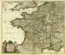
Title: Accuratißima Galliæ Tabula : Gallis Vulgo dicta le Royaume de France divisa tam in Præfecturas generales quam in Provincias separatas cum regionibus
Subtitle:
Publisher:
ex officina Frederici de Wit, cum privil. D. Ord. Holl. et Westfrisiæ
Place of publishing:
Description:
Skala [ca 1:2 400 000], podziałka liniowa: Milliaria Gallica Horæitineris ; 1 mapa : miedzior., kolor. ręcznie ; 49x58 cm ; Południk zerowy Ferro ustalony po obliczeniach przez katalogującego ; W ramce opisano strony świata: Septentrio, Oriens, Meridies, Occidens ; Data wyd. związana z datą otrzymania przywileju przez F. de Wita w 1688 r. Oficyna wydawnicza przestała istnieć ok. 1709 r.
Detailed Resource Type:
Format:
Resource Identifier:
Source:
CBGiOŚ. IGiPZ PAN, call no. B.1643[7] ; click here to follow the link
Language:
Rights:
Terms of use:
Digitizing institution:
Institute of Geography and Spatial Organization of the Polish Academy of Sciences
Original in:
Projects co-financed by:
Programme Innovative Economy, 2010-2014, Priority Axis 2. R&D infrastructure ; European Union. European Regional Development Fund
Access:
Object collections:
- Institute of Geography and Spatial Organization PAS (IGiPZ PAN) > Library
- Institute of Geography and Spatial Organization PAS (IGiPZ PAN) > Library > Maps and atlases
Last modified:
Mar 25, 2021
In our library since:
Mar 21, 2014
Number of object content downloads / hits:
134
All available object's versions:
https://www.rcin.org.pl/igipz/publication/42396
Show description in RDF format:
Show description in RDFa format:
Show description in OAI-PMH format:
Objects Similar
Wit, Frederick de (1630–1706)
Wit, Frederick de (1630–1706)
Wit, Frederick de (1630–1706)
Wit, Frederick de (1630–1706)
Wit, Frederick de (1630–1706)


